A Life Without Limits
  • Surveying
    • Surveying Roles
      • Overall Breakdown
      • Licensed and Registered Surveyors
    • Specialisations and Related Fields
      • Specialisations
      • Civil Engineering
      • Geospatial Science
      • Hydrography
    • The History of Surveying
    • Technology
      • Surveying Technology
      • 3D Scanning
      • GPS
      • Drones
      • Pokémon and Surveying
      • GDA2020 – Modernising Australia’s Datum
    • Cool Projects
    • Defining Surveying
  • Profiles
    • Meet a Current Surveying Student
    • Meet a Survey Assistant
    • Meet a University Student Project of the Year Winner
    • Meet a Graduate Surveyor
    • Meet a 3D Modeller and Surveyor
    • Meet a Trainee Licensed Surveyor
    • Meet a Newly Licensed Surveyor
    • Meet a Senior Licensed Surveyor
    • Young Surveying Professional of the Year
    • Professional Surveyor of the Year
    • Meet a Senior Lecturer in Surveying
    • Meet a Surveyor General
    • Women in Surveying
  • Study
    • NSW & ACT >
      • Study Pathways
      • Where To Study
      • NSW Scholarships
    • QLD >
      • Study Pathways
      • Where To Study
      • Qld Scholarships
    • SA >
      • Study Pathways and Institutions
    • VIC >
      • Work Experience Placements
      • Study Pathways
      • Where To Study
      • RMIT Information Portal
    • WA >
      • Study Pathways
      • Where To Study
    • Distance >
      • Distance Education
  • Career Resources
    • Get Kids into Survey
    • Career Resources
  • Experience Surveying
    • Try Surveying in Victoria
    • Try Surveying in NSW
  • Industry Partners
  • Connect with Industry
    • Find a Job
    • Work Experience
  • More Info
    • Blog
    • Ask a Surveyor
    • Is Surveying for Me?
    • Surveying and STEM careers
    • Demand for Surveyors
    • In the News
    • Videos
      • Videos About Surveying
      • Surveying With Evan Webster
      • Women in Surveying Day
      • Student Experience Days
    • FAQs
    • Contact Us

Pokémon and Surveying

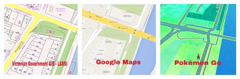
What does surveying have to do with Pokémon?

If you’re not already on your quest to ‘catch ‘em all’, you’ve no doubt heard about Pokémon Go – the wildly popular game that has people of all ages walking the streets staring at their phones (and sometimes walking into stationary objects) in search of virtual Pokémon.

What you may not have heard about is the technology that makes the game possible.

Pokémon Go allows you to find and catch Pokémon located all around you using a Geographic Information System, or GIS. A GIS is a database of information that pinpoints different features to a location such as property boundaries and building locations. Google Maps is one of the most well known GIS that has been created over many years using a combination of government cadastral data, satellite imagery and data collected by Google via GPS and Street View imagery.

Cadastral or land surveyors are responsible for defining land parcel boundaries and road alignments that make up the government cadastre, which is the basis for the world of Pokémon Go.

So what you’re actually seeing when you spot that cute little Charmander down the street is geographic data generated in large part by surveyors.

The app uses the GPS in your phone to locate you and place your avatar at your location on the ‘gamified’ Geographic Information System. Pokémon are then populated at certain coordinates within the GIS reference frame and displayed in the ‘real world’ creating an augmented reality with your camera.

Geographic markers also assist in determining what types of Pokémon are in certain locations — for example, water-based Pokémon can only be found near water. “We assign values based on whether there is a water body in an area — so a stream, a river, a pond — whether areas are designated as zoos or parks, or other kinds of mapping designations,” John Hanke, CEO of Niantic said.

The use of maps and GPS makes Pokémon Go a uniquely active, social game, taking gamers out of their bedrooms and into the ‘real world’. “There’s a stereotypical image of a gamer in 2016, a couch potato who never leaves the house, who never really enjoys [the] outdoors. The gamer playing Pokémon Go? That person is outdoors all the time”, commented the New York Daily.

Similarly, surveyors who formed Pokémon Go’s GIS framework enjoy working outdoors in a variety of locations – no two work days are alike. There may not be a world of Pokémon through the lens of a surveyor’s equipment; however unlike Pokémon trainers, surveyors are able to see future towns and cities and map the world around them.

So if you have a keen interest in geography or technology, surveying could be the career for you.

Contact Us

New South Wales
T: (02) 9054 6867

Queensland
T: (07) 3321 1622

South Australia
T: (08) 8212 0343

Western Australia
T:  0424 177 510

Victoria
T: (03) 9690 6660

News

  • Is Land Surveying a Hands-on Role?
  • Have You Thought About Studying Land Surveying at TAFE?
  • What Course Do I Need to Complete to Become a Land Surveyor in Victoria?
  • Thinking of Becoming a Land Surveyor? Here’s What You Need to Know

Pathways

  • Study Pathways – NSW
  • Study Pathways – QLD
  • Study Pathways – SA
  • Study Pathways – VIC
  • Study Pathways – WA

Join us

© Copyright 2020. A Life Without Limits | Surveying Task Force Inc.