
As clever and dedicated as surveying professionals are, they can’t do their jobs all alone. Ever since human beings developed the concept of land ownership, the surveyor has been there with equipment in hand to help determine land boundaries.
You can read all about the ancient history of surveying technology here – and about its recent history here – but what about its future?
The truth is, as the role of the surveyor has developed, so too has the technology – and a profession that used to rely on a rope with knots tied into it, today works with drones and robotic total stations. Of course, even today’s technology continues to develop, and there are even some modern trends that we can use to look ahead and get a sense of what surveyors might be working with in the future.
The advances in LiDAR
LiDAR technology is achieving more with each passing year. The technology traces its birth back to the early 1960s, but the advances of recent times – and those promised by the years to come – are truly changing the game.
LiDAR, which stands for Light Detection and Ranging, is a surveying method which uses laser light points and a sensor to measure the distance to a target. By registering the differences in the return times of millions of laser points, it is possible to use LiDAR systems to create digital 3D models of that target. The technology has progressed to such a point today that the data point clouds that it produces can make high resolution maps. There are even specialised forms of LiDAR technology, designed to be utilised in land, sea or air scenarios.
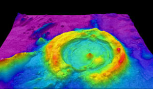
An example of a 3D digital scan of the seabed, achieved using LiDAR technology.
The future for 3D laser scanning is looking even more ambitious, with LiDAR systems now available that are capable of producing this data set in real time. This will provide a major advantage in the coming years; surveyors will be able to work much more quickly, and projects will be afforded a lot more flexibility.
The proliferation of LiDAR technology also means that this real time 3D scanning process – once upon a time only available for high profile, high budget projects – will be readily available at all levels in the industry.
Look to the skies
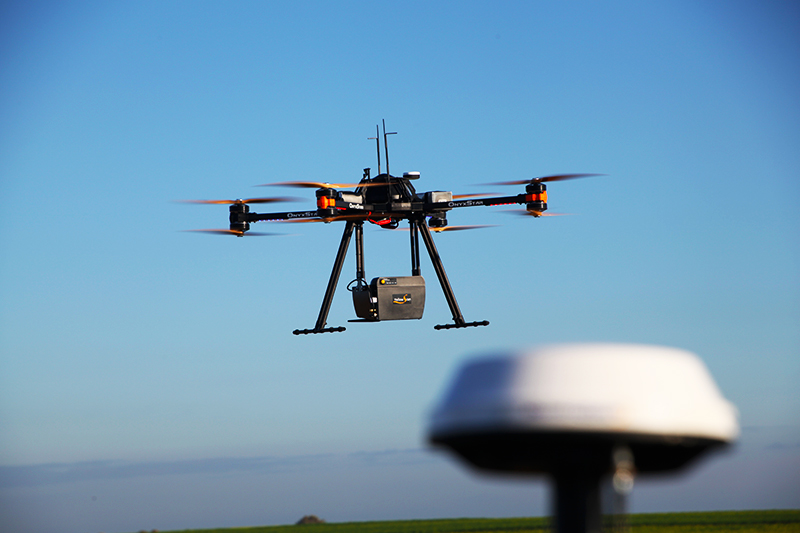
The recent rise of drones in the surveying industry – no pun intended – has been widely reported. Like LiDAR systems, these unmanned aerial vehicles (UAVs) became more affordable and are well on their way to becoming an integral part of the surveyor toolkit.
UAVs can provide a unique perspective that the terrestrial surveyor couldn’t achieve without them. From the air, they can capture anything from a 2D or 3D map crafted from stitched-together images, to a thermal map registering heat signatures, to a LiDAR high-density point cloud. It all depends on what equipment is attached to the rig.
They are now beginning to leverage the power of other surveying and geographic data tools. For example, satellite systems can enhance accuracy dramatically.
Surveyors with their heads in the clouds
Speaking of the clouds that these high-flying drones drift through, the future of cloud data storage is also looking bright.
With more effective ways to collect data – such as the aforementioned LiDAR and UAVs – comes more data to manage. Storing data becomes increasingly difficult, and as such the ongoing advances in cloud storage systems are growing ever-more important in the surveying profession.
If it were not for the storage solutions offered by cloud data storage, many surveying firms would soon not be able to cater for multiple projects on the go. They often wouldn’t be able to pursue new projects and clients until their current assignments reach the end of their life.
We are not short on reasons why the surveying profession will no doubt be more wedded to these kinds of storage systems in the future. For one, cloud-based storage offers greater power resources than a local computer, which can help surveyors process large swathes of information more quickly. Utilising cloud-based systems also makes it easier for different companies or groups to collaborate on a project; and then there is the promise of a remote storage system that will not require the maintenance and upkeep on their end that a local system would.
What to know more?
If you find the technology side of surveying fascinating, you’re in luck – the tech of tomorrow is looking like it will achieve fantastic things and really push the profession forward.
To get an in-depth breakdown on some of the things surveying tech can do, you can explore this very website. Head here to read all about a few projects that utilised 3D laser scanning techniques, then visit this page to investigate the connection between surveying and Pokémon Go.